Posts

Showing posts with the label Lindon

Grove Creek - Battle Creek Loop, 8.5

Image
I met up with Sean for the middle section of his 14-miler (Dry Canyon - Grove Creek Loop).  I parked at the mouth of Battle Creek and caught Sean who had started twenty-five minutes early at Dry Canyon.  We followed the dirt roads north along the bench to Grove Creek, ran up the steep Grove Creek trail to Indian Springs (One of my favorite places in all of Utah County), and then I let him continue along the Curly Springs Trail to Dry Canyon while I ran down Battle Creek and returned home just in time to help shuttle kids to soccer games. My phone crashed half way through, and I forgot to start my watch, so I don't have the exact mileage or a map.  I have done this run backward several times - click here for that to see that info.  Indian Springs

Battle Creek to Grove Creek 8.3

Image
This is an all-time favorite trail. Brian, Jeff, Craig and I decided to meet at Grove Creek (500 North in Pleasant Grove). We ran south on the Bonneville Shoreline trail and then headed up Battle Creek Canyon. It was nice to get this section of the loop out of the way up front. It was a beautiful morning, and the view of Mt. Timpanogos covered with snow was spectacular. Battle Creek Falls  Grove Creek Trailhead (Finish) We did this same trail  last August . The grass was much taller then.

Dry Canyon Trail 051 (7.3) - Lindon, Utah

Image
The Trailhead: Take the 1600 N Orem/Lindon Exit and head east. Turn left on Skyline Drive and then right on Dry Canyon Road. 31 minutes from East Spanish Fork (my home). There are many trail options from this trailhead.  We chose a great one: Trail 051.  After a 3/4 mile steep climb turn right and switch back up to a beautiful view of Lindon/Orem.  This trail takes you South before heading further east for a spectacular view of Provo Canyon, Mount Baldy, and Timp. Trail 51 comes out at the Orem water towers.  Take the Bonneville Shoreline Trail back to Dry Canyon Trailhead. Here are some pics.  Watch the sky change as the sun comes up.

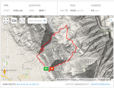
Battle Creek to Grove Creek - 8.5

Image
This is definitely a top 10 trail in Utah County.  The trail starts at the end of 200 South in Pleasant Grove (South of the "G"on the mountain), and follows Battle Creek up the canyon. There is an amazing waterfall just a half mile up this trail. The waterfall is a popular destination for hikers, and most turn around there. After the waterfall, the trail continues a very steep ascent and tops out at the base of Utah County's majestic Mount Timpanogos.  From there, take a left and run a little more than a mile through the beautiful meadows on the back side of G Mountain.  Then take a left at "Indian Campground" and head down Grove Creek Canyon.  Note: there is a great spring at Indian Campground to fill up your water bottles.  Follow the Bonneville Shoreline Trail from the base of Grove Creek to back to the Battle Creek Trailhead to complete the loop. click here to see the course on Mapmyrun.com  Battle Creek - above the falls  Beaut...