Posts

Showing posts from 2016

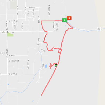
Hot Pots - Last Run of 2016, 12.25 miles

Image
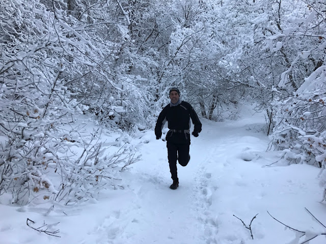
Who gets up at 5:00 AM on New Year's Eve? I was tempted to sleep in, but really wanted to do this trail in the snow.  This was my first run with the South Utah County Trail Runners .  We met at the Jack Rabbit Chevron at the mouth of Spanish Fork Canyon and the five of us piled into Sean's Truck. We drove up the canyon to the Diamond Fork turnoff on the left.  From there we drove to the closed gate at the Palmyra Campground.   It was about 3 miles from the gate to the Three Fork's Trailhead, and then another three miles up 5th Water to the Hot Pots. Sean, Roberto, Monte, Tyler, Adam I enjoyed listening to inspiring stories from these four along the way. These are some tough trail runners. Roberto and Sean Adam and Tyler experienced a second wind on the way down. It was a chilly morning as you can see by the frost on Adam and Tyler's beards. Thanks to this group fo

Trail 051 - Orem Water Tower / Dry Canyon Loop, 7.1

Image
It was a calm, clear and beautiful 34 degree morning on Trail 051 today. We started at the Orem Bench Trailhead.  We ran the BST north, then up Dry Creek Canyon to Trail 051 past the south side of Little Baldy, then down to "The Alter" and back to the trailhead.   Part way up the trail we heard laughter and loud conversation.  The fun and adventurous group was world record holder,  James Lawrence , aka "The Iron Cowboy" and his team.  With how much fun these guys were having, you would never guess that they are actually some pretty serious athletes, having just recently completed  50 triathlons in 50 states in 50 days  - absolutely amazing! As you can see, there are numerous variations for endless hours of exploration in the beautiful area. Looking down Dry Canyon "The Alter" - Five trails intersect at this location

The Forbidden Trail of Mud and Bones, 5.94 mi

Image
The sound of rain throughout the night tempted us to call off this morning's run.  But we decided to give it a try. We drove through flooded streets in the rain on the way to Mapleton Canyon.  On the map it looks like the Bonneville Shoreline Trail starts at Mapleton Canyon and heads South.  Private property has blocked the trail however.  After about a mile the rugged pipeline road ended and the old Bonneville Shoreline Trail began.  We ran for another mile on the much better trail before turning around. We assumed there must be a different access to the BST, so we tried two different dirt roads heading west toward Mapleton, but both of them ended at private property behind locked gates.  It was a miserable, mushy, slippery and wet run. After heading downhill a second time, we decided to jump a fence and finish the run on pavement.  In the end, it was a fun early morning adventure.  I plan to scout out access to this trail another day.   By the end of this six-mil

Bonneville Shoreline Trail from Springville Running North - in Snow

Image
This is a great trail with lots of rollers for a good workout!  We just had our first BIG snow storm, so we were the first to break through the powder.  We saw 20 or 30 deer.  And the view of the valley with fresh snow was fantastic.   Sean at our turn-around spot. I believe this is an old mine. This guy looks like TROUBLE!