Posts

Showing posts from 2015

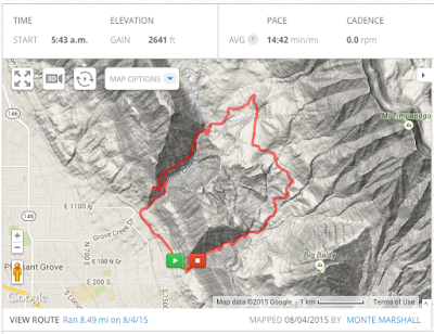
Bidal Veil to Indian Road (Provo Canyon), 5.0

Image
Thanks to Brian for today's run.  After taking the month of September off, it was nice to hit the trails again. It was cool, but not too cold.  And we got to see an amazing sunrise over Utah Lake.  The fall leaves were still on the trees and covering the ground.  All in all, it was a great start to the weekend. Timp at Dawn Brian, Monte, and Jeff  Three great runners!  Brian, Craig, and Jeff

Game Trails - Spanish Fork

Image
Thanks to Dennis for showing me this trail that runs along the Spanish Fork East Bench, above the Salem Canal. The after leaving the canal road, the trail is pretty thing and a little overgrown for the first mile or so.  It then opens up to a double track trail.  We turned around at mile three, but I am told that this trail will go all the way to the Dream Mine property.  We started at the parking lot just north of the Spanish Oaks Golf Course and ran up Powerhouse Road until to the Canal.  This is a fun trail run, close to home. 

Battle Creek to Grove Creek - 8.5

Image
This is definitely a top 10 trail in Utah County.  The trail starts at the end of 200 South in Pleasant Grove (South of the "G"on the mountain), and follows Battle Creek up the canyon. There is an amazing waterfall just a half mile up this trail. The waterfall is a popular destination for hikers, and most turn around there. After the waterfall, the trail continues a very steep ascent and tops out at the base of Utah County's majestic Mount Timpanogos.  From there, take a left and run a little more than a mile through the beautiful meadows on the back side of G Mountain.  Then take a left at "Indian Campground" and head down Grove Creek Canyon.  Note: there is a great spring at Indian Campground to fill up your water bottles.  Follow the Bonneville Shoreline Trail from the base of Grove Creek to back to the Battle Creek Trailhead to complete the loop. click here to see the course on Mapmyrun.com  Battle Creek - above the falls  Beautiful view

Big Springs (Top of South Fork, Provo Canyon) to Rock Canyon - 12.36 miles

Image
As much as I love standing on top of the Cascade Saddle, overlooking Squaw Peak and Provo, this run is not for the faint of heart.  Miles 3-5 are VERY STEEP and the terrain is rough with many sections of loose rocks.  Miles 6 and 7 are steep down with poor terrain.  This trail took much longer than anticipated - of course we are not in the same kind of shape as we were when we did this run in 2011 so we are partly to blame.  None-the-less, be prepared for a grueling and beautiful experience. And don't roll an ankle! By the way, we saw two monstrous bull moose, and a few deer as well.