Hidden Oak Trail in the Dark - Spanish Oaks Reservoir
Get link
Facebook
X
Pinterest
Email
Other Apps
I decided this morning that this trail is meant to be done in the light. It is very steep and fairly rocky. We made to nearly to the top of the switchbacks before turning back.
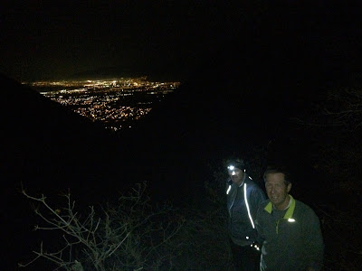
It was a beautiful view of the valley lights from the switchbacks. Sean and Brian were like mountain goats on this trail.
On a 93 degree day, this trail was the perfect choice. The Hidden Oak Trail (also known as Snell Canyon) starts at the end of the road just east of Spanish Oaks Reservoir. Most of the trail is through thick oak and pine trees, so it is very shaded. Bring your bug spray as there were a lot of flies and gnats, particularly the first half mile. It's only 1.25 miles to the overlook , but it feels further because of the climb. From that point the trail gradually starts to disappear in the tall grass and shrubs, though many people will bushwhack much further up Snell Canyon. Highlight: playing with a spotted fawn who kept running up the trail and then waiting for me to catch up. The trail is a gradual climb until just over one mile, at which point there are two steep switch backs leading to an amazing view of the Spanish Fork City and River Bottoms. Other fun trails in this area include: Look Out Point, Escalante Cr...
The Trailhead: Take the 1600 N Orem/Lindon Exit and head east. Turn left on Skyline Drive and then right on Dry Canyon Road. 31 minutes from East Spanish Fork (my home). There are many trail options from this trailhead. We chose a great one: Trail 051. After a 3/4 mile steep climb turn right and switch back up to a beautiful view of Lindon/Orem. This trail takes you South before heading further east for a spectacular view of Provo Canyon, Mount Baldy, and Timp. Trail 51 comes out at the Orem water towers. Take the Bonneville Shoreline Trail back to Dry Canyon Trailhead. Here are some pics. Watch the sky change as the sun comes up.
This was a killer climb, and very rocky. 966 ft. in the first mile alone. 4,082 ft. overall elevation gain. The front of the mountain looks a little dry, especially during the current drought. But by mile four, we were running through luscious green trees, and bushes with red berries and yellow flowers. I was joined by Matt Seeley and Garritt Page. Garritt is the brother of Lalena Page, a former college teammate of mine. Matt and Garritt were mountain goats on the uphill. Pics below are out of order, but you can see exactly where they were taken on Strava . Coordinates to the trailhead: 40.039171596858544, -111.63391146714346
Comments
Post a Comment